
Ganga Updates
Ganga River Map: Complete Route, Source, Tributaries & Major Cities
Published
7 hours agoon
By
Raju Patel
The Ganga River stretches across 2,525 kilometers of Indian land, making it the longest river flowing entirely within Indian borders. More than 400 million people depend on its water for drinking, farming, and daily survival. That makes the Ganga basin one of the most densely populated river basins on the entire planet. If you want to trace the full path of this mighty river on a map, you are in the right place.
This article gives you a complete picture of the Ganga River map. You will learn exactly where it starts, which direction it flows, what tributaries feed into it, and which major cities sit along its banks. Whether you are a student, a traveler, or just someone curious about Indian geography, this guide breaks everything down in plain and simple language.
Where Does the Ganga River Start?
The Ganga River begins high up in the Himalayas. Its official source is the Gangotri Glacier, located in the Uttarkashi district of Uttarakhand, India. The glacier sits at an altitude of about 3,892 meters above sea level. A small ice cave at the snout of this glacier is called Gaumukh, which literally means “cow’s mouth” in Hindi.
From Gaumukh, the river first flows as a stream called Bhagirathi. Many people think the Ganga starts at Gangotri town, but the actual origin point is Gaumukh, which is about 19 kilometers upstream from the town. The area is remote, cold, and surrounded by snow covered peaks. Pilgrims and trekkers visit Gaumukh every year to see the birthplace of India’s most sacred river.
The Bhagirathi flows down from Gaumukh through narrow mountain valleys. It passes through several small towns in Uttarakhand before reaching a place called Devprayag. This is where the real story of the Ganga River map begins to get interesting.
Devprayag: Where the Ganga Gets Its Name
At Devprayag, two major mountain rivers meet. The Bhagirathi River coming from Gangotri joins the Alaknanda River arriving from the Satopanth Glacier near Badrinath. The moment these two rivers merge, the combined flow officially becomes the Ganga River.
Devprayag sits at an elevation of about 472 meters. The meeting point of the two rivers is a stunning sight. The Bhagirathi carries slightly darker water while the Alaknanda appears clearer. You can actually see the two colors blending together at the confluence. This town is one of the Panch Prayags, which are five sacred confluences in the Uttarakhand hills.
The Alaknanda River itself is formed by several smaller confluences upstream. It collects water from rivers like the Mandakini at Rudraprayag and the Pindar at Karnaprayag. So by the time the Alaknanda reaches Devprayag, it already carries a huge volume of water from multiple Himalayan streams.
The Upper Course of the Ganga River
After Devprayag, the Ganga continues flowing southwest through the Himalayan foothills. This upper section of the Ganga River route is steep and fast. The river cuts through narrow gorges and dense forests. It passes through the town of Rishikesh, which is famous for yoga, adventure sports, and the iconic Lakshman Jhula footbridge.
From Rishikesh, the river moves to Haridwar, one of the holiest cities in Hinduism. Haridwar is the point where the Ganga leaves the mountains and enters the flat northern plains of India. This transition is significant on the Ganga River map because the river changes character completely here. It goes from a fast, narrow mountain stream to a wide, slow moving plains river.
At Haridwar, a canal called the Upper Ganga Canal diverts a portion of the river’s water for irrigation. The Ganga canal system built by the British in the 1800s still serves millions of farmers in Uttar Pradesh. Haridwar also hosts the famous Kumbh Mela, a massive religious gathering that attracts millions of devotees.
The Middle Course: Across the Great Plains
Once the Ganga leaves Haridwar, it enters the vast Indo Gangetic Plain. This flat region stretches across most of northern India. The river flows generally southeast through the states of Uttar Pradesh and Bihar. This middle section is the longest part of the Ganga River route, and it passes through some of India’s most important cities.
The river first flows through Uttar Pradesh, passing near the cities of Bijnor, Narora, and Farrukhabad. It continues to Kannauj, an ancient city that was once the capital of Emperor Harsha’s kingdom in the 7th century. The river here is wide and slow, spreading across sandy floodplains during the monsoon season.
Further downstream, the Ganga reaches Kanpur, one of the largest industrial cities along its banks. Kanpur is a major manufacturing hub, but it is also one of the biggest sources of pollution entering the river. Factories and sewage treatment gaps have created serious environmental problems in this stretch.
Prayagraj: The Sacred Confluence
The next major landmark on the Ganga River map is Prayagraj, formerly known as Allahabad. This city holds enormous religious importance because it is where the Ganga meets the Yamuna River. Hindus also believe a mythical third river called the Saraswati joins underground at this point.
The meeting of the Ganga and Yamuna at Prayagraj is called the Triveni Sangam. It is considered one of the holiest spots in all of Hinduism. The Kumbh Mela held here is the largest human gathering on Earth, with over 100 million people attending during the 2019 event. After absorbing the Yamuna’s water, the Ganga grows significantly wider and carries much more volume.
Varanasi: The Spiritual Heart
Downstream from Prayagraj, the Ganga reaches Varanasi, also known as Banaras or Kashi. This city is one of the oldest continuously inhabited cities in the world, with a history stretching back over 3,000 years. Varanasi sits on the left bank of the river and is defined by its famous ghats, which are stone steps leading down to the water.
There are over 80 ghats in Varanasi. Pilgrims come from all over India and the world to bathe in the Ganga here. Cremation ceremonies take place at Manikarnika Ghat and Harishchandra Ghat around the clock. The evening Ganga Aarti ceremony at Dashashwamedh Ghat draws thousands of spectators every single night. For anyone studying the Ganga River map, Varanasi is the spiritual center of the entire river system.
Into Bihar
After Varanasi, the river crosses into Bihar, passing through the city of Patna. Patna, the state capital of Bihar, is an ancient city known historically as Pataliputra. It was the capital of several powerful Indian empires, including the Maurya and Gupta dynasties.
Near Patna, the Ganga receives water from several large tributaries coming down from Nepal and the sub Himalayan region. The river here is extremely wide during the monsoon months, sometimes stretching several kilometers across. Flooding is a regular and serious problem in Bihar, affecting millions of people every year.
Major Tributaries of the Ganga River
The Ganga does not flow alone. It collects water from dozens of tributaries along its path. These tributaries are a crucial part of the Ganga River map because they contribute most of the river’s total water volume. The tributaries come from both the left bank (north side) and the right bank (south side).
Left Bank Tributaries (from the Himalayas):
The northern tributaries originate in the Himalayan mountains and carry large amounts of water, especially during the monsoon. The Ramganga joins near Kannauj. The Gomti flows through Lucknow before meeting the Ganga near Varanpur. The Ghaghara, also called Sarju, is one of the largest tributaries by water volume and joins near Chapra in Bihar. The Gandak flows down from Nepal and meets the Ganga near Hajipur. The Kosi River, often called the “Sorrow of Bihar” because of its devastating floods, joins near Kursela.
Right Bank Tributaries (from Peninsular India):
The southern tributaries are generally shorter and carry less water. The Yamuna is the most important right bank tributary and the largest one overall. It flows 1,376 kilometers from Yamunotri in the Himalayas through Delhi and Agra before joining the Ganga at Prayagraj. The Son River originates in Madhya Pradesh and joins near Patna. The Damodar River enters the Ganga system in West Bengal.
| Tributary | Bank | Confluence Point | Origin |
|---|---|---|---|
| Yamuna | Right | Prayagraj | Yamunotri Glacier |
| Ghaghara | Left | Chapra, Bihar | Tibet (Mansarovar) |
| Gandak | Left | Hajipur, Bihar | Nepal Himalayas |
| Kosi | Left | Kursela, Bihar | Nepal/Tibet border |
| Son | Right | Near Patna | Amarkantak, MP |
| Ramganga | Left | Near Kannauj | Uttarakhand hills |
| Gomti | Left | Near Varanpur | Pilibhit, UP |
| Damodar | Right | West Bengal | Chota Nagpur Plateau |
These tributaries together drain an area of over 1 million square kilometers, creating one of the largest river basins in the world. The Ganga basin covers parts of India, Nepal, Bangladesh, and a tiny portion of China.
The Lower Course: Entering Bengal
After flowing through Bihar, the Ganga enters West Bengal. This is where the lower course of the river begins. Near the town of Farakka in the Murshidabad district, something very important happens on the Ganga River map. The river splits into two main branches.
One branch continues flowing east into Bangladesh, where it is known as the Padma River. The other branch turns south and flows through West Bengal as the Hooghly River, also called Bhagirathi in its upper reaches within Bengal. The Farakka Barrage, a large dam built in 1975, controls how much water goes into each branch. This barrage has been a source of tension between India and Bangladesh for decades.
The Hooghly River and Kolkata
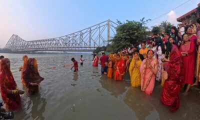
The Hooghly River flows south through West Bengal, passing through the city of Kolkata, which is India’s third largest metropolitan area. Kolkata was built on the banks of the Hooghly and served as the capital of British India until 1911. The Howrah Bridge, one of the most famous bridges in India, spans the Hooghly and connects Kolkata to Howrah city.
The Hooghly is a tidal river, meaning its water levels rise and fall with ocean tides even though it is still many kilometers inland. Ships and cargo vessels use the Hooghly to reach Kolkata port, one of the oldest operating ports in the country. As the Hooghly flows further south past Kolkata, it widens dramatically before emptying into the Bay of Bengal.
The Ganges Delta
The area where the Ganga and its branches meet the sea is called the Ganges Delta. This is the largest river delta on Earth, covering approximately 59,000 square kilometers. The delta spans both India and Bangladesh. On the Indian side, much of it falls within the Sundarbans, a massive mangrove forest that is home to the Royal Bengal Tiger.
The Sundarbans is a UNESCO World Heritage Site and one of the most unique ecosystems in the world. Hundreds of small islands, channels, and waterways make up this region. The land here is low lying and extremely vulnerable to cyclones, flooding, and rising sea levels caused by climate change.
The Ganga finally meets the Bay of Bengal through multiple mouths spread across the delta. There is no single point where the river ends. Instead, it fans out into countless channels that blend fresh river water with salty ocean water. This mixing zone supports an incredibly rich variety of fish, birds, and marine life.
Major Cities Along the Ganga River
The Ganga River map passes through or touches dozens of cities and towns. Here is a summary of the most important ones from source to sea.
Starting in Uttarakhand, Rishikesh and Haridwar are the first significant cities. Moving into Uttar Pradesh, the river flows past Bijnor, Narora, Kannauj, Kanpur, Prayagraj, Mirzapur, and Varanasi. Each of these cities has deep historical and cultural roots tied to the river.
In Bihar, Buxar, Ballia (on the UP border), Patna, Munger, and Bhagalpur are key cities along the banks. Patna stands out as the largest city in this section and serves as the political capital of Bihar. After entering West Bengal, the river passes through Murshidabad, Nabadwip, and eventually Kolkata via the Hooghly channel.
Across the border in Bangladesh, the Padma branch flows through Rajshahi and joins the Brahmaputra near Goalundo before reaching the sea. The Ganga River system, when you include the Bangladesh section, touches hundreds of millions of lives across two countries.
Religious and Cultural Significance
No discussion of the Ganga River map is complete without talking about the river’s cultural importance. The Ganga is considered the holiest river in Hinduism. According to Hindu mythology, the goddess Ganga descended from heaven to earth to purify the souls of ancestors. This story is central to why Hindus consider bathing in the Ganga a sacred act.
Every year, millions of pilgrims visit cities like Haridwar, Prayagraj, and Varanasi to perform rituals on the river’s banks. The Kumbh Mela, held every 12 years at Prayagraj and other locations, is the largest peaceful gathering of humans anywhere in the world. The river is part of daily life for hundreds of millions of people, from morning prayers to funeral rites.
Even people who do not follow Hinduism recognize the Ganga’s cultural power. Buddhists, Jains, and Sikhs all have historical connections to cities along the Ganga. Emperor Ashoka’s capital Pataliputra, Guru Nanak’s visits to Varanasi, and Mahavira’s connection to Bihar all tie back to the river’s geography.
Environmental Challenges Facing the Ganga
The Ganga is one of the most polluted rivers in the world, and this is a serious problem that affects every section of the Ganga River map. Industrial waste from cities like Kanpur, untreated sewage from Varanasi and Patna, and agricultural runoff from millions of farms all pour into the river daily.
Studies have found dangerously high levels of fecal coliform bacteria, heavy metals, and toxic chemicals in many stretches of the river. The Central Pollution Control Board of India has classified several sections as unfit for bathing or drinking without treatment. Despite this, millions of people still use the river water directly because they have no other option.
The Indian government launched the Namami Gange Programme in 2014 with a budget of over 20,000 crore rupees to clean and protect the river. The program focuses on building sewage treatment plants, reducing industrial discharge, and conserving biodiversity along the river. Progress has been slow, but some improvements have been reported in certain stretches.
Climate change adds another layer of concern. The Gangotri Glacier, which feeds the river, has been retreating at an alarming rate. Studies show the glacier is shrinking by about 22 meters per year. If this trend continues, the river’s water flow during dry months could decrease significantly in the coming decades, affecting water supply for hundreds of millions.
The Ganga River Basin: A Broader View
When you look at the Ganga River map from a basin perspective, you see a massive drainage system. The Ganga basin covers about 26 percent of India’s total land area. It stretches across 11 Indian states, including Uttarakhand, Uttar Pradesh, Madhya Pradesh, Rajasthan, Haryana, Himachal Pradesh, Chhattisgarh, Jharkhand, Bihar, West Bengal, and Delhi.
The basin also extends into Nepal, where several major tributaries like the Kosi, Gandak, and Ghaghara originate. In Bangladesh, the combined Ganga and Brahmaputra system creates the Bengal Delta, supporting one of the most densely populated regions on the planet.
About 43 percent of India’s total irrigated land lies within the Ganga basin. The river and its tributaries support agriculture that feeds a significant portion of India’s 1.4 billion people. Rice, wheat, sugarcane, and lentils are the major crops grown in the basin area. Without the Ganga and its network of canals and tributaries, Indian agriculture would face a catastrophic crisis.
How to Read a Ganga River Map
If you are looking at a Ganga River map for study or travel purposes, here are some helpful tips. Start at the top left of the map in Uttarakhand, where the river originates. Trace the blue line as it moves southeast through Uttar Pradesh and Bihar. Notice how the river gets wider as more tributaries join it along the way.
Pay attention to the major confluence points. Devprayag, Prayagraj, and Farakka are the three most important junctions on the map. At each of these points, the river changes in size, name, or direction. Also look for the canal systems branching off from the main river, especially near Haridwar and Farakka, as these carry significant amounts of water away from the main channel.
In the delta region, the map becomes more complex because the river splits into many smaller channels. The border between India and Bangladesh runs through this delta, so political boundaries add another layer to the geography. Good maps will show both the Hooghly branch going south through Kolkata and the Padma branch going east into Bangladesh.
Interesting Facts About the Ganga River
The Ganga has a unique property that scientists have studied for years. The river water contains bacteriophages, which are viruses that kill harmful bacteria. This partially explains why the water resists putrefaction longer than water from many other rivers. Some researchers believe this property contributed to the ancient belief that Ganga water is pure and sacred.
The Ganga dolphin, also known as the Susu, is a freshwater dolphin species found only in the Ganga and Brahmaputra river systems. It was declared India’s national aquatic animal in 2009. The species is endangered, with an estimated population of only 1,200 to 1,800 individuals remaining. Pollution and habitat loss are the biggest threats to their survival.
The river also supports one of the largest inland fisheries in the world. Over 140 species of fish have been recorded in the Ganga system. Fishing provides livelihood to millions of families living along the river’s banks in Uttar Pradesh, Bihar, and West Bengal.
Conclusion
The Ganga River map tells the story of a river that is much more than just water flowing across land. From its icy origins at Gaumukh in the Himalayas to its sprawling delta in the Bay of Bengal, the Ganga covers 2,525 kilometers and touches the lives of nearly half a billion people. It collects water from powerful tributaries like the Yamuna, Ghaghara, Gandak, and Kosi. It flows past ancient cities like Varanasi and Patna, and it supports agriculture, industry, and spiritual life across a vast basin.
But the river faces real threats. Pollution, glacier retreat, and overuse of water are all putting pressure on this vital resource. Programs like Namami Gange offer hope, but much more work is needed. Every person living in the Ganga basin and every citizen of India has a role to play in protecting this river for future generations.
If you found this guide helpful, share it with students, travelers, and anyone interested in Indian geography. Bookmark this page for future reference, and explore our other articles on major rivers of India to deepen your knowledge of the country’s incredible water systems.
You may like
Ganga Updates
Ganga Platino: Premium Apartments, Amenities, Location & Price Guide
Published
1 day agoon
July 4, 2026By
Raju Patel
Introduction:
Pune’s real estate market grew by over 18% in 2023, making it one of the fastest growing property markets in India. Buyers are looking harder than ever for projects that give real value. Ganga Platino is one name that keeps coming up in those conversations.
This project sits in one of Pune’s most active residential zones. It offers a mix of smart design, strong amenities, and a location that connects residents to work, schools, and daily needs without much hassle. If you are thinking about buying or investing, this guide will walk you through everything you need to know.
We cover the apartment configurations, amenities, exact location benefits, price details, and what makes this project stand out. By the end, you will have a clear picture to help you make a smart decision.
What Is Ganga Platino?
Ganga Platino is a premium residential project developed by Ganga Developers, a well known name in Pune’s real estate sector. The project is located in Kharadi, one of the most sought after neighborhoods in Pune. It was designed to offer high quality urban living at a competitive price point.
Ganga Developers has built a strong reputation over the years. Their projects are known for quality construction, on time delivery, and designs that focus on space and light. Ganga Platino follows the same standard and adds a few extra touches that make it feel truly premium.
The project targets working professionals, young families, and investors who want a property in a high growth area. It is not just about four walls and a roof. It is about living in a community that is thoughtfully built.
Location: Why Kharadi Is the Right Place to Be
Kharadi is one of the most important growth corridors in Pune. It is home to major IT parks, corporate offices, and business hubs like EON IT Park and World Trade Center Pune. This makes it a top choice for tech professionals and business executives who want to live close to work.
The location of Ganga Platino gives residents easy access to key parts of the city. Nagar Road connects directly to central Pune. The airport is just a short drive away. Major hospitals, schools, and malls are all within a comfortable distance.
Connectivity is one of the biggest selling points here. The area is well served by public transport and main road networks. Whether you drive, use a cab, or take a bus, getting around from Kharadi is relatively smooth compared to many other parts of Pune.
Nearby Key Locations from Ganga Platino
| Landmark | Approximate Distance |
|---|---|
| EON IT Park | 1 to 2 km |
| World Trade Center Pune | 2 to 3 km |
| Pune International Airport | 8 to 10 km |
| Phoenix Marketcity Mall | 4 to 5 km |
| Columbia Asia Hospital | 3 to 4 km |
| Symbiosis International University | 6 to 8 km |
Kharadi also has a strong social infrastructure. You will find good restaurants, grocery stores, gyms, and entertainment options all nearby. Living here means you spend less time commuting and more time doing things that matter.
Apartment Configurations: What You Get
Ganga Platino offers multiple apartment configurations to suit different needs and budgets. The project includes 2 BHK and 3 BHK apartments, covering a good range of buyers from small families to larger households.
The 2 BHK units are designed for couples, small families, or professionals who want a spacious yet manageable home. These units make efficient use of every square foot. The rooms are well proportioned and get good natural light.
The 3 BHK apartments are for buyers who need more space. These are great for growing families or people who work from home and need a dedicated office space. The layouts are open and avoid the boxy feel that many apartments carry.
Key Features of the Apartments
Every unit in Ganga Platino has been planned with practical living in mind. Here are some of the standout interior features:
- Large windows that bring in natural light and ventilation
- Premium quality flooring in living rooms and bedrooms
- Modular kitchen designs with quality fittings
- Spacious balconies in most units
- High quality bathroom fittings and fixtures
- Ample storage space built into the design
The floor plans are available from the developer’s sales office and website. It is worth requesting a detailed floor plan before shortlisting your preferred unit. This helps you understand how the space is divided and whether it fits your lifestyle.
Amenities: What Life at Ganga Platino Looks Like
A premium project is not just about the apartment itself. It is also about what happens outside your front door. Ganga Platino has invested in building a set of amenities that support a balanced lifestyle for all age groups.
Fitness and Wellness Facilities
Residents have access to a fully equipped gymnasium. There is no need for an outside gym membership when you have quality equipment right in your building. A swimming pool is also available, which is a great feature for both fitness and relaxation.
Yoga and meditation areas are part of the layout too. These spaces are quiet and designed to give residents a place to unwind. For a city as busy as Pune, having a calming space at home makes a real difference.
Children’s Play and Recreation
Families with kids will find dedicated play areas inside the complex. These are safe, enclosed spaces where children can be active without parents worrying about road traffic or safety issues. The design keeps children’s areas separate from vehicle movement zones.
Indoor games rooms are also available. These spaces support community interaction and give teenagers and adults a place to spend leisure time within the property.
Green Spaces and Open Areas
Ganga Platino has landscaped gardens and open areas within the project. Green spaces help reduce the urban heat effect and give residents a place to walk, sit, and breathe. The project has tried to balance built structures with open green zones.
Tree lined pathways and sitting areas are thoughtfully placed throughout the complex. These are not just decorative. They serve a real purpose by giving the community a sense of calm within a busy city.
Security and Safety
Security is a top priority at Ganga Platino. The project uses a multi layer security system that includes CCTV surveillance, trained security personnel, and access control at all entry and exit points. Residents feel safe at all times of day and night.
Fire safety systems are installed throughout the building. Each floor has proper fire escape plans and equipment in place. Emergency response systems are also part of the project’s safety infrastructure.
Other Amenities Worth Noting
The project includes a clubhouse that can be used for community events and private gatherings. A multipurpose hall is available for residents who want to host functions within the complex. A co working space or business center is also available in some configurations, which is very useful for remote workers.
Ample parking space is provided for residents and visitors. Electric vehicle charging points are being integrated into newer projects by Ganga Developers, and Ganga Platino aligns with this modern thinking.
Construction Quality and Design Philosophy
One of the most common questions buyers ask is about construction quality. Ganga Developers uses RCC framed structure construction, which provides strength and durability. The walls, floors, and ceilings are built to last, not just to look good at first glance.
The design philosophy focuses on functional elegance. Spaces are not oversized to inflate the price. Every part of the apartment is designed to be used efficiently. This makes the homes feel generous without being wasteful.
The building facade has a clean and contemporary look. The architecture does not try too hard to impress. Instead, it focuses on simple lines, good proportions, and materials that age well. This is the kind of design that looks as good in ten years as it does today.
Ganga Developers also focuses on sustainable construction where possible. Energy efficient lighting, water saving fixtures, and rainwater harvesting systems are features that reduce environmental impact and also lower monthly utility bills for residents.
Price Guide: What Does Ganga Platino Cost?
Pricing is always one of the first things buyers want to know. Ganga Platino offers competitive pricing for a premium project in Kharadi. The exact price depends on the floor, facing, and unit size you choose.
As of the most recent data available, the approximate price range for units at Ganga Platino is as follows. A 2 BHK apartment typically starts around Rs. 85 to 100 lakhs depending on the configuration. A 3 BHK apartment typically falls in the range of Rs. 1.2 to 1.6 crores.
These prices reflect the location advantage, construction quality, and amenity package that comes with the project. Compared to similar projects in Kharadi and neighboring areas like Viman Nagar and Hadapsar, Ganga Platino offers fair value.
What Affects the Final Price?
Several factors can change the final price you pay. Floor level matters because higher floors with better views and less noise often carry a premium. East or west facing units can also have different price points based on sunlight and ventilation.
The stage of construction also matters. Buying during the pre launch or early launch phase often gets you a better rate than buying when the project is close to completion. This is why many smart investors come in early.
Additional Costs to Plan For
Beyond the base price, buyers should plan for some additional costs. Stamp duty in Maharashtra is typically around 5% of the property value, with registration charges adding around 1%. Ganga Platino also has a maintenance deposit and monthly maintenance fees that vary by unit size.
Interior finishing, furniture, and appliances are separate costs that buyers often underestimate. Setting aside 10 to 15% of the property value for these expenses is a reasonable plan. A home loan from a major bank can cover the primary purchase cost, and Ganga Platino is approved by several top lenders.
Investment Potential: Should You Buy in Ganga Platino?
Kharadi is one of the strongest property investment zones in Pune right now. The area has seen consistent rental demand because of the nearby IT corridor. Professionals working in EON IT Park, World Trade Center, and other offices prefer to stay in Kharadi to avoid long commutes.
Rental yields in Kharadi typically range between 3% and 4.5% per year, which is solid for a city like Pune. A 2 BHK in this area can fetch anywhere between Rs. 20,000 and Rs. 30,000 per month as rental income. This makes Ganga Platino attractive for buyers who want passive income from their property.
Capital appreciation has also been strong. Properties in Kharadi have increased in value steadily over the last several years. Infrastructure development, new office projects, and better road connectivity continue to push prices higher. Buying now puts you ahead of future price growth.
If you are looking at long term wealth building, buying in a premium project like Ganga Platino in a high demand location is a sound strategy. The combination of good rental income and solid appreciation makes it one of the better options in Pune’s residential market.
Who Is Ganga Platino Best Suited For?
Not every project fits every buyer. Ganga Platino works best for a specific group of people. Knowing whether you fall into that group helps you decide faster.
IT professionals working in Kharadi or nearby areas are the best fit. The location cuts down commuting time significantly, and the lifestyle amenities match the needs of working adults. Families with children also benefit from the safe environment, play areas, and proximity to good schools.
First time home buyers who want a quality product at a reasonable price point will find Ganga Platino a strong option. The project offers enough premium features without going into ultra luxury pricing territory. You get real value for what you pay.
Investors looking for a rental income property in Pune will also find this project appealing. The demand for rental housing in Kharadi is consistently high, and a well maintained premium apartment in this area rents quickly at good rates.
Ganga Developers: Who Is Behind This Project?
A project is only as good as the developer behind it. Ganga Developers has been active in Pune’s real estate market for many years. They have delivered multiple residential and commercial projects across the city with a strong track record.
Buyers trust Ganga Developers because of their consistency in construction quality and delivery timelines. In a market where delays are common, the developer’s history of on time possession gives buyers confidence. Their after sales service and maintenance record are also well regarded.
The company has received recognition from industry bodies for their contributions to Pune’s residential landscape. Their portfolio covers projects in areas like Undri, Keshav Nagar, and Kharadi. Each project reflects a similar focus on quality, space planning, and community living.
Doing a background check on any developer before buying is always a good idea. For Ganga Developers, the track record speaks clearly. The RERA registration of the project adds another layer of buyer protection that is important in today’s real estate market.
RERA Registration and Legal Transparency
Any residential project sold in India must be registered under RERA, which stands for Real Estate Regulatory Authority. Ganga Platino is RERA registered, which means the developer is bound by legal rules that protect buyers.
RERA registration means the developer must disclose all project details including layout plans, completion timeline, and financial accounts. Buyers can track the project’s progress on the RERA portal at any time. This transparency reduces the risk of being misled.
If there are delays or issues with the project, RERA gives buyers a legal path to seek compensation or resolution. This is an important safeguard that was not available to buyers before RERA came into force. Always verify the RERA number on the Maharashtra RERA website before finalizing your purchase.
How to Book an Apartment at Ganga Platino
Booking a unit at Ganga Platino is a straightforward process. The first step is visiting the site office or the developer’s official website to check availability. Unit availability changes based on how quickly other buyers are booking.
After selecting your preferred unit, you pay a token amount to hold the unit. This is followed by a formal booking form and a booking amount as defined by the developer. The sales team will then guide you through the payment schedule and documentation process.
Most buyers also explore home loan options at this stage. Ganga Platino is pre approved by leading banks and NBFCs, which simplifies the loan process. You can compare loan offers from different lenders and choose the one with the best terms.
Site visits are strongly recommended before booking. Walking through the property, checking the construction, and seeing the location firsthand gives you information that no brochure can fully provide. If possible, visit on a weekday and a weekend to get a realistic picture of the area.
Common Questions Buyers Ask About Ganga Platino
Is Ganga Platino ready to move in?
The possession status depends on the phase and unit you choose. Some phases may be ready for possession while others are under construction. Check with the sales team for updated possession timelines.
Can NRIs buy apartments at Ganga Platino?
Yes. NRIs can purchase residential property in India, and Ganga Platino follows standard procedures for NRI buyers. Most major banks also offer NRI home loans for such purchases.
What is the maintenance charge at Ganga Platino?
Maintenance charges vary by unit size and are typically charged on a monthly or quarterly basis. The exact amount should be confirmed with the developer as it may change based on the project phase and amenities included.
Is there a parking facility at Ganga Platino?
Yes. Covered parking is available for residents. The allocation depends on the unit type, and the developer provides clear details on parking during the booking process.
Tips for Buying Smartly at Ganga Platino
Buying a premium apartment is a big financial decision. A few simple steps can help you make the most of it. First, always compare the cost per square foot across similar projects in Kharadi before committing. This tells you whether the pricing is fair.
Second, read the agreement carefully before signing. Pay attention to the possession date, penalty clauses for delays, and what happens if there are changes to the layout or amenities. A lawyer can help you review the document if needed.
Third, check your home loan eligibility before finalizing the unit. Knowing how much the bank is willing to lend helps you plan your budget realistically. Avoid stretching your finances to the maximum limit, as property ownership comes with ongoing costs.
Finally, visit the site in person. Photos and virtual tours are helpful but they cannot replace a real site visit. Walk the area, talk to people in the neighborhood, and check the actual apartment floor plan against the measurements provided. This due diligence pays off in the long run.
Conclusion: Is Ganga Platino Worth It?
Ganga Platino brings together a strong location, quality construction, practical amenities, and fair pricing in one package. For anyone looking to buy a premium apartment in Pune, it deserves serious consideration.
The Kharadi location alone is a major advantage. Add to that the track record of Ganga Developers, the lifestyle amenities on offer, and the solid investment potential of the area, and you have a project that checks most of the right boxes. It is not perfect for everyone, but for the right buyer, it is a very strong option.
If you are a working professional, a family, or an investor focused on Pune’s east corridor, Ganga Platino is worth a closer look. Take the time to visit the project, talk to the sales team, and compare your options before deciding.
Ganga Updates
The Hidden Wonders of Ram Ganga River
Published
2 weeks agoon
June 24, 2026By
Manoj Bala
Most people know about the Ganges, the Yamuna, and maybe the Brahmaputra. But there is a river flowing through the heart of Uttarakhand that remains surprisingly overlooked. The Ram Ganga River stretches over 596 kilometers from the lower Himalayas to the plains of Uttar Pradesh. It feeds millions of people, supports one of India’s most famous national parks, and holds centuries of cultural significance. Yet very few travelers or nature lovers give it the attention it truly deserves.
This article will take you through the many hidden wonders of the Ram Ganga River. You will learn about its geography, its incredible wildlife, its cultural roots, and the challenges it faces today. Whether you are a student, a nature enthusiast, or someone planning a trip to Uttarakhand, this piece has something valuable for you. Let us explore why this river matters far more than most people realize.
Where Does the Ram Ganga River Begin?
The Ram Ganga River originates in the Doodhatoli ranges of the Pauri Garhwal district in Uttarakhand. These ranges sit at an elevation of roughly 3,110 meters above sea level. The river begins as a small stream in these cold, forested mountains before growing into a full river as it moves south.
From its origin, the Ramganga flows through the Kumaon hills, picking up water from several smaller streams and seasonal channels along the way. It passes through dense forests, rocky gorges, and open valleys. The terrain it crosses is some of the most beautiful and least visited in all of northern India.
After leaving the hills, the river enters the plains near the town of Kalagarh in Uttarakhand. This is where the Ramganga Dam stands, one of the most important structures along the river. From there, it continues through parts of Uttar Pradesh before eventually joining the Ganges near Kannauj. The total distance it covers makes it one of the significant left bank tributaries of the Ganges.
Two Rivers Share One Name
Here is something that confuses many people. There are actually two rivers called Ramganga. One is the western Ram Ganga, which is the larger and more well known of the two. The other is the eastern Ramganga, which flows through the Pithoragarh district and eventually merges with the Sharda River near the Nepal border.
The western Ram Ganga River is the one most references point to when discussing Corbett National Park, the Ramganga Dam, and the major irrigation systems in Uttar Pradesh. The eastern Ramganga, while smaller, also holds ecological and cultural importance. Both rivers contribute to the larger Ganges basin, but they follow very different paths through very different landscapes.
For the purpose of this article, we will focus mainly on the western Ram Ganga River since it carries more historical, ecological, and economic weight. However, knowing that two rivers share this name helps avoid confusion when reading maps or travel guides.
The Lifeline of Jim Corbett National Park
If you have ever heard of Jim Corbett National Park, then you have already encountered the influence of the Ram Ganga River without knowing it. Corbett is India’s oldest national park, established in 1936. The Ramganga flows right through its core zone, creating one of the richest wildlife habitats in the country.
The river provides drinking water for tigers, elephants, deer, and dozens of other species inside the park. During the dry months, the Ramganga becomes the primary water source for animals across large stretches of forest. Without it, the ecosystem inside Corbett would look very different.
Birdwatchers especially love the Ramganga corridor. Over 600 species of birds have been recorded in and around Corbett National Park. Many of these birds depend on the river and its banks for food, nesting, and shelter. Species like the crested serpent eagle, the great hornbill, and various kingfishers are regularly spotted near the water. The river creates a natural gathering point for wildlife, making it one of the best places in India for photography and observation.
The Ramganga Reservoir, formed by the dam near Kalagarh, has also become a haven for mugger crocodiles and gharials. These reptiles were once widespread across Indian rivers but have lost much of their habitat over the decades. The reservoir gives them a relatively safe environment to breed and grow. Conservation programs in the area have helped stabilize some of these populations, though challenges remain.
Rich Aquatic Life Beneath the Surface
Most people admire rivers for their surface beauty. But the real magic of the Ram Ganga River happens beneath the water. The river supports a wide variety of freshwater fish, many of which are native to the Himalayan foothills and found nowhere else on earth.
The golden mahseer is perhaps the most famous fish in the Ramganga. This powerful freshwater fish can grow over a meter in length and weigh more than 25 kilograms. Anglers from around the world consider it one of the most exciting sport fish on the planet. The mahseer population in the Ramganga has faced pressure from pollution and overfishing, but conservation efforts have made a difference in recent years.
Other notable fish species in the river include the snow trout, various species of catfish, and the goonch. The goonch is a large predatory catfish that has gained something of a legendary status. Some specimens have reportedly exceeded 80 kilograms. These fish thrive in the rocky, fast moving sections of the upper Ramganga where the water is cold and well oxygenated.
Freshwater mussels and various invertebrates also call the Ramganga home. These smaller creatures play a huge role in keeping the river clean by filtering water and breaking down organic matter. They form the base of a food chain that supports everything from fish to birds to large mammals on the riverbanks.
The Ramganga Dam and Its Impact
The Ramganga Dam, located near Kalagarh at the edge of Corbett National Park, was completed in 1974. It is an earth and rock fill dam standing about 128 meters tall. The reservoir behind it can store roughly 2.45 billion cubic meters of water. This makes it one of the most important water storage structures in northern India.
The dam serves several critical purposes. It provides irrigation water to over 600,000 hectares of farmland in Uttar Pradesh. It also generates hydroelectric power and helps control flooding in downstream areas during the monsoon season. For the agricultural communities in the Gangetic plain, the Ramganga Dam is genuinely essential.
However, the dam has also created challenges. It has altered the natural flow of the river, which affects fish migration patterns. Species like the mahseer, which need to move upstream to spawn, find the dam an impassable barrier. Sediment that would normally flow downstream and enrich the floodplains now settles behind the dam instead. This changes the character of the river below the dam and affects farming communities that once relied on natural silt deposits.
The reservoir itself has created a large body of still water where a flowing river once existed. This has changed local microclimates and affected some plant and animal species. On the positive side, the reservoir attracts migratory birds during winter, creating a secondary wildlife habitat that did not exist before.
Balancing the benefits of the dam with its environmental costs is an ongoing discussion among engineers, ecologists, and local communities.
Sacred and Cultural Significance
Rivers in India are never just bodies of water. They carry deep spiritual meaning, and the Ram Ganga River is no exception. For the communities living along its banks in Uttarakhand and Uttar Pradesh, the Ramganga holds a sacred place in daily life and religious practice.
Several temples and pilgrimage sites sit along the Ramganga. Devotees perform rituals at the river’s banks during festivals and auspicious days. The river is considered a purifier, much like its larger parent, the Ganges. In many villages, the Ramganga is the center of community life. Weddings, funerals, and seasonal celebrations all have some connection to the river.
In the Kumaon region, folk songs and stories often reference the Ramganga. It appears in local literature as a symbol of life, resilience, and natural beauty. Older generations pass down tales about the river to younger ones, keeping its cultural importance alive even as modern life changes the landscape around it.
The connection between people and the Ram Ganga River goes back hundreds of years. Archaeological evidence suggests that settlements along the Ramganga existed well before recorded history in the region. The river provided water for drinking, farming, and trade. It shaped the geography of human habitation in ways that are still visible today.
Forests and Landscapes Along the Ramganga
The Ram Ganga River passes through some of the most stunning natural landscapes in India. In its upper reaches, dense forests of oak, pine, and rhododendron cover the hillsides. These forests are home to leopards, Himalayan black bears, and langur monkeys. The air is cool, the water is crystal clear, and the silence is broken only by birdsong and the sound of rushing water.
As the river descends into the Shivalik hills and enters Corbett territory, the vegetation changes. Sal forests dominate this zone, creating thick canopies that shelter a wide range of animals. Tall grasses grow along the riverbanks, providing cover for tigers and their prey. This stretch of the Ramganga is arguably the most ecologically productive section of the entire river.
Below the dam, the landscape shifts again. The river enters flatter terrain, and the forests give way to farmland and small towns. The water moves more slowly here, spreading out into wide channels during the monsoon. Wetlands and marshes form along the edges, supporting a different but equally important set of plant and animal species.
Each section of the Ramganga has its own character and its own set of natural wonders. Traveling along the river from source to mouth would feel like passing through several completely different worlds.
Threats Facing the Ram Ganga River
Like many rivers in India, the Ram Ganga River faces serious threats. Some are old problems that have grown worse over time. Others are newer challenges brought on by rapid development and population growth.
Pollution is the most visible threat. As the river passes through towns and cities, it collects untreated sewage, industrial waste, and agricultural runoff. The water quality drops significantly between the upper reaches and the plains. In some stretches near urban areas, the river is too polluted for drinking or even bathing.
Sand mining is another major concern. Sand from the riverbed is extracted for use in construction. While some level of sand removal can be sustainable, the scale of mining along the Ramganga has exceeded safe limits in many areas. This destabilizes the riverbanks, increases erosion, and destroys habitats for fish and other aquatic life.
Deforestation in the upper catchment areas reduces the ability of the land to absorb rainwater. This leads to more severe flooding during the monsoon and lower water levels during dry months. The loss of tree cover also increases soil erosion, which adds sediment to the river and reduces water quality further.
Climate change is altering rainfall patterns in the region. Some years bring excessive rain and devastating floods. Other years see drought like conditions that leave the river dangerously low. These unpredictable swings make life harder for both wildlife and human communities along the Ramganga.
Conservation Efforts and Hope for the Future
Despite the challenges, there are reasons to be hopeful about the future of the Ram Ganga River. Several conservation programs are working to protect and restore the river and its surrounding ecosystems.
The Wildlife Institute of India has conducted studies on the Ramganga’s role within Corbett National Park. These studies have helped shape management policies that balance tourism, wildlife protection, and water use. Buffer zones around the park limit development in sensitive areas, though enforcement remains a challenge.
Local communities in Uttarakhand have started grassroots efforts to clean river sections and plant trees along the banks. These community led projects may be small in scale, but they create real change at the local level. They also build awareness among younger generations about the importance of protecting natural water systems.
The government’s Namami Gange program, which focuses on cleaning and rejuvenating the Ganges and its tributaries, includes the Ramganga in its scope. Funding has been allocated for sewage treatment plants and pollution monitoring along the river. Progress has been slow in some areas, but the inclusion of the Ramganga in a national level program is a positive step.
Fish conservation programs focused on the golden mahseer have also shown results. Controlled breeding and release programs, combined with stricter fishing regulations in some zones, have helped stabilize mahseer populations in parts of the river. These programs demonstrate that targeted conservation action can make a real difference.
Visiting the Ram Ganga River
If you want to experience the beauty of the Ram Ganga River firsthand, there are several excellent options. The easiest and most popular way is through a visit to Jim Corbett National Park. The park offers jeep safaris that follow routes along the river, giving visitors a chance to see wildlife in its natural habitat.
For those who prefer a quieter experience, the upper reaches of the Ramganga near Doodhatoli offer trekking opportunities through forests and along mountain streams. These areas see fewer tourists, which means a more peaceful and authentic connection with nature. However, infrastructure in these regions is limited, so plan accordingly.
Fishing enthusiasts can find guided mahseer fishing trips along certain stretches of the river. These trips are often catch and release, supporting conservation while allowing anglers to enjoy the thrill of hooking one of the world’s great freshwater fish. Always check local regulations before fishing, as some areas have seasonal restrictions.
The best time to visit the Ramganga depends on what you want to see. Winter months from November to February are ideal for birdwatching and wildlife viewing. The monsoon season from July to September shows the river at its most powerful but also makes many areas inaccessible. Spring and early summer offer pleasant weather and good visibility.
How the Ramganga Supports Local Economies
The economic importance of the Ram Ganga River extends far beyond the dam and its irrigation channels. Entire communities depend on the river for their daily livelihoods.
Farmers in the plains of Uttar Pradesh rely on Ramganga water for growing rice, wheat, sugarcane, and vegetables. The canal system fed by the Ramganga Dam reaches hundreds of thousands of hectares of farmland. Without this water, food production in the region would drop dramatically. This single river contributes to the food security of millions of people.
Fishing communities along the river earn their living from the Ramganga’s aquatic resources. While commercial fishing has declined in some areas due to pollution and overfishing, it still supports thousands of families. Sustainable fishing practices, if properly implemented, could help these communities thrive for generations.
Tourism related to the Ramganga also generates significant income. Corbett National Park attracts over 200,000 visitors annually, many of whom come specifically for the river and the wildlife it supports. Hotels, guides, transport services, and local shops all benefit from this tourism economy. The river is, in a very real sense, the engine that drives Corbett’s tourism industry.
Lesser Known Facts About the Ram Ganga River
Even people familiar with the Ramganga often miss some of its most interesting details. Here are a few facts that might surprise you.
The Ramganga’s water temperature varies dramatically from source to mouth. Near its origin in the Doodhatoli ranges, the water temperature can drop below 5 degrees Celsius during winter. By the time it reaches the plains of Uttar Pradesh, summer temperatures can push the water above 30 degrees Celsius. This range creates vastly different habitats along the river’s length.
The river has been mentioned in historical texts dating back several centuries. British era records from the 1800s describe the Ramganga as a “sportsman’s paradise” due to the abundance of fish and wildlife along its banks. Jim Corbett himself, the famous hunter turned conservationist after whom the national park is named, wrote about the Ramganga in his books. His descriptions of the river and its surroundings helped bring international attention to the region.
The Kalagarh Dam reservoir sometimes reveals remnants of old villages that were submerged when the dam was built. During years of low water levels, foundations and remnants of structures become visible. These ghostly reminders speak to the human cost of large infrastructure projects and the communities that were displaced.
The Ramganga also plays a role in groundwater recharge. As the river flows through sandy and porous terrain in the plains, water seeps into underground aquifers. These aquifers supply wells and tube wells used by millions of people. The health of the Ramganga directly affects the availability and quality of groundwater across a large region.
The Connection Between Ramganga and the Ganges
As a major tributary of the Ganges, the Ram Ganga River contributes significantly to the health and volume of India’s most sacred river. The Ramganga meets the Ganges near Kannauj in Uttar Pradesh, adding substantial flow during both the monsoon and dry seasons.
The quality of water that the Ramganga delivers to the Ganges matters a great deal. If the Ramganga carries heavy pollution loads, that pollution transfers directly into the Ganges. Cleaning the Ramganga is therefore not just about protecting one river. It is about protecting the entire Ganges basin and the hundreds of millions of people who depend on it.
Scientists who study river systems in India increasingly recognize that you cannot fix the Ganges without fixing its tributaries first. The Ramganga is one of the most important tributaries in terms of both water volume and pollution contribution. Efforts to improve water quality in the Ramganga have a multiplied positive effect downstream.
This interconnection also means that ecological improvements along the Ramganga benefit the broader Ganges ecosystem. Fish populations, bird migration routes, and nutrient cycles all connect across these river systems. A healthy Ram Ganga River means a healthier Ganges, and ultimately, a healthier environment for one of the most densely populated regions on Earth.
What You Can Do
You do not need to be a scientist or a government official to help protect the Ram Ganga River. Small actions by ordinary people add up over time and create meaningful change.
If you visit the Ramganga or Corbett National Park, practice responsible tourism. Do not litter, stay on designated paths, and follow park rules. Choose local guides and services that prioritize sustainability. Your choices as a tourist send a message to the local economy about what kind of development is welcome.
Support organizations working on river conservation in India. Many nonprofits and community groups focus on cleaning rivers, planting trees, and monitoring water quality. Even a small donation or volunteer effort can help these groups expand their work.
Talk about the Ramganga. Share what you have learned with friends, family, and on social media. Awareness is the first step in building the public support needed for stronger environmental protections. The more people know about the hidden wonders of the Ram Ganga River, the harder it becomes for decision makers to ignore its needs.
Reduce your own water footprint. Every drop of water you save reduces pressure on rivers like the Ramganga. Simple changes like fixing leaks, using water efficient appliances, and being mindful of water use in daily life all contribute to a larger solution.
Conclusion
The Ram Ganga River is one of India’s most underappreciated natural treasures. From its origins in the misty mountains of Doodhatoli to its merger with the Ganges in the plains of Uttar Pradesh, it sustains wildlife, feeds farms, powers communities, and carries deep cultural meaning. It flows through one of the world’s most famous national parks and supports species found nowhere else on earth.
Ganga Updates
The Ganga River Unprecedented Low Streamflow and Its Implications
Published
7 months agoon
December 1, 2025By
Raju Patel
As the sacred waters of the Ganga, revered by millions, ebb to unprecedented lows, a silent crisis unfolds along its banks. Once a roaring lifeline that nourished countless communities and ecosystems, India’s holiest river now faces alarming challenges that threaten not only its flow but also the very fabric of life intertwined with it. From agricultural distress to dwindling fish populations and increasing pollution levels, the implications are vast—and urgent. Join us as we delve deep into this pivotal moment in history, exploring what these low streamflows mean for both people and nature alike. Together, let’s navigate through this complex tapestry of tradition, ecology, and survival in one of the world’s most vital waterways.
Introduction to the Ganga River and its historical significance
The Ganga River, a sacred lifeline for millions in India, has long been revered not just as a waterway but as an embodiment of culture and spirituality. Stretching over 2,500 kilometers, it weaves through the heart of the subcontinent, nourishing cities and villages alike. Historically significant, this river has witnessed the rise and fall of civilizations while providing sustenance to countless communities along its banks.
However, today’s reality presents a stark contrast to its storied past. The Ganga faces an unprecedented crisis marked by dangerously low streamflow levels that threaten both ecological balance and human livelihoods. As we navigate this pressing issue together—understanding its causes and implications—we uncover why action is imperative for preserving one of India’s most precious resources.
The current crisis: Reasons for low streamflow and the impact on communities
The Ganga River, once a robust lifeline for millions, now faces an alarming decline in streamflow. Several factors contribute to this crisis. Rapid urbanization leads to increased water extraction and pollution, straining the river’s resources.
Moreover, extensive damming projects disrupt natural flow patterns. These infrastructures are vital for irrigation and power generation, but compromise the ecological balance of the river.
Communities that depend on the Ganga face dire consequences. Farmers struggle as fields dry up, lacking sufficient irrigation. Fishermen see dwindling catches affecting their livelihoods and food security.
Additionally, local populations suffer from inadequate access to clean drinking water due to declining river levels. The cultural significance of the Ganga adds another layer; rituals tied to its waters become increasingly challenging as sacred sites experience lower flows.
Examining the role of climate change in the situation
Climate change is a significant factor behind the Ganga River’s unprecedented low streamflow. Rising temperatures have led to altered precipitation patterns across India. This means less rain during critical monsoon months, impacting river levels dramatically.
Glacial melt from the Himalayas also plays a crucial role. As global warming accelerates, glaciers retreat faster than before. This phenomenon reduces the long-term supply of freshwater that feeds into the Ganga.
Moreover, extreme weather events—such as unpredictable droughts and heavy flooding—are becoming more common. These fluctuations disrupt local ecosystems and affect communities reliant on the river for sustenance and livelihood.
The intertwined relationship between climate change and water resources highlights an urgent need for adaptive strategies. Stakeholders must recognize these challenges to formulate effective responses tailored to preserving this vital waterway.
India’s response: Proposed changes to the Ganges water-sharing treaty with Bangladesh
India’s response to the crisis surrounding the Ganga River has been multifaceted, particularly in relation to its water-sharing agreement with Bangladesh. The unprecedentedly low streamflow has raised urgent concerns about equitable access.
One major proposal involves renegotiating aspects of the Ganges Water Sharing Treaty established in 1996. This treaty aimed for a fair distribution but may now be inadequate given current environmental challenges.
The Indian government is exploring options that could enhance cooperation with Bangladesh while ensuring both nations can address their growing water needs. Discussions are likely to focus on adaptive management strategies and enhanced monitoring systems.
Additionally, there’s emphasis on joint initiatives for sustainable water usage and conservation practices along shared riverbanks. Strengthening diplomatic ties through dialogue will be essential as both countries navigate these pressing issues together.
Global implications of the Ganga River crisis
The Ganga River crisis extends far beyond India’s borders. As one of the most important rivers in South Asia, its health is vital for regional ecosystems and economies. The Ganga serves millions who depend on it for agriculture, drinking water, and livelihoods.
When streamflow decreases, neighboring countries feel the repercussions too. Bangladesh relies heavily on cross-border water sharing with India. Reduced flow can lead to disputes over resources that could escalate into political tensions.
Moreover, a diminished Ganga compromises biodiversity within its watershed. Unique species face habitat loss due to changing water levels. This situation disrupts local fishing industries that many communities rely upon for sustenance.
Internationally, the plight of the Ganga raises alarms about climate resilience and sustainable practices worldwide. Observers look closely at how this river’s fate echoes larger patterns of environmental degradation across vulnerable regions globally.
Possible solutions and steps towards sustainability
To address the Ganga River crisis, a multi-faceted approach is essential. First, we must enhance water conservation techniques across agriculture. Implementing rainwater harvesting can significantly reduce dependency on river flow.
Another avenue lies in restoring wetlands along the riverbanks. These natural systems act as buffers, absorbing excess water during floods and releasing it slowly during dry spells. Community engagement plays a pivotal role, too. Educating local populations about sustainable practices ensures they understand their impact on this vital resource.
Additionally, investing in modern waste management systems can help alleviate pollution levels in the Ganga. Cleaner waters contribute to better streamflow and healthier ecosystems. Lastly, fostering international cooperation with neighboring countries like Bangladesh is crucial for equitable water-sharing agreements that benefit all parties involved while preserving this sacred river’s integrity.
Conclusion: Why we need to take action now for the future of the Ganga River.
The Ganga River, a lifeline for millions, faces an unprecedented crisis. With streamflow at alarmingly low levels, the implications extend far beyond its banks. Communities reliant on this sacred waterway are grappling with dwindling resources and shifting ecosystems.
Urgent action is required to address the multifaceted challenges posed by climate change and unsustainable practices. The proposed changes to the Ganges water-sharing treaty with Bangladesh signal a critical step towards collaborative management of this vital resource. However, more needs to be done.
Sustainability must become a priority in policymaking and community engagement alike. Innovative approaches that balance ecological health with human needs will be essential as we move forward.
Every moment counts for the future of the Ganga River and all those who rely on it. It’s time for individuals, communities, governments, and organizations worldwide to unite in safeguarding this irreplaceable treasure before it’s too late. Taking proactive steps today can ensure that future generations experience not just a river but an enduring legacy of hope and life flowing through their lands.
Trending
-
 Tech5 months ago
Remote Work: A Complete Guide to Working from Anywhere
-
 Tech5 months ago
Twizchat.com: The Future of Real-Time Online Communication
-
 Tech6 months ago
Top 10 Digital Printing Companies in Chicago
-

 Ganga Quest12 months ago
Ganga Quest
-
 Ganga Updates11 months ago
Latest News, Photos, Videos on Ganga Floods
-
 Lifestyle6 months ago
Creative Grounding Techniques for Everyday Stress Relief
-

 Tech11 months ago
InternetChocks: Understanding Their Role in Online Security
-
 Business5 months ago
FedEx: A Complete Guide to Services, Shipping Costs, and Global Logistics